| Map: | Sheet OL7 The English Lakes: SE area |
| Start: | Arnside (junction of the Promenade and Silverdale Road) (SD456787) |
| Route: | There is plenty of variety in this short walk: woods, coast, views across to the Lake District and of course the Arnside Knott (which has the distinction of being the smallest Marilyn. The route along the coast may not be passable at extreme high tides (although there are alternative paths) and there are potentially dangerous drops from the cliff top sections. |
| More info: | More about Arnside from Wikipedia and about the Arnside/Silverdale AONB. |
| Parking: | On road along The Promenade, or a small car park near the railway viaduct. |
| Buses & trains: | Visit North West Journey Planner |
| Refreshments: | A choice of pubs and tea rooms in Arnside. |
|
|
|
Walk up Silverdale Road, the road between the Albion pub and a signpost to Arnside Knott. Follow the road uphill and round bends to road junction. Turn right along Redhills Road. After less than 100 metres bear left along High Knott Road. This road bends sharply to the left and takes you past a row of large detached and semi-detached houses. Before reaching the end of this road follow a fingerpost on the right, through a kissing gate into Redhills Wood. Exit the wood through another kissing gate, set in a stone wall. | |
|
For a short distance follow the wall, but as the wall curves to the left, continue ahead.
There are a group of trees head - head to the right of these to a gate in the stone wall.
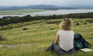
Do pause to admire the view behind, across Morecambe Bay to the Lake District.
Immediately through the gate, bear right, then after a few metres the path divides again.
The main path is the one on the right, the left fork leads to the trig point. If you follow this,
turn right at the trig point to rejoin the main path further along.
Take the right hand fork where the path divides as you enter a group of trees. Go through a kissing gate (by the side of a larger wooden gate). At the viewpoint plaques show what you can see in each direction, from the Lake District summits to the islands off the Furness peninsula. Re-trace your steps through the kissing gate. When you meet the main path, turn right. The path descends, fairly steeply in places. Follow a sharp bend to the left and continue downhill. Cross another path and go through gate. Just through the gate bear left. The path follows the left hand boundary wall to a wooden stile and gate. The stile leads you out of National Trust property to a narrow path between a post and wire fence on left and a stone wall on right. Go through aluminium gate by Hollins Farm. Turn right over stile, following finger post to Far Arnside and Park Point. Leave the field through another gated stone stile. Turn right on to road, signed public footpath, Arnside via Park Point. |
|
|
Follow the single track road into Holgates Holiday Park. At fork, follow the road to the right, signed for White Creek.
Where road forks again, walk to the left (no entry for vehicles). At the hairpin bend in road, continue ahead on footpath
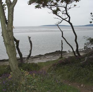
. By a signs back to Far Arnside and warning of danger from fast rising tides take the path on the left, towards the shore. The narrow path skirts the top of limestone cliffs, threading in and out of woodland. The path is uneven, and there are places with dangerous drops to rocks below on left. After rounding Park and Arnside Points there is a small bay on left. Look out for gap in wall on left. Go through gap and also take the next left hand fork (if it high tide, you may wish to go right here, and rejoin the route at New Barns). Follow the path down on to the stone covered beach. Walk towards the northern end of the bay. Walk over rocky outcrops at Blackstone Point. Look out for a path on right, leading from the beach into the wood. Follow the path round to the left, where it follows the clifftops in and out of the woods once again. |
|
|
The path descends to another stony beach from which the railway viaduct at Arnside comes into view.
The path curves inland, past cottages at New Barns. Turn left on to narrow concrete track, then just
before the road passes flood defences, take path on left.
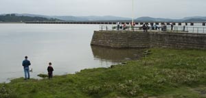
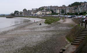
We continued along the beach, then joined a concrete path. The path passes in front of a coast guard station, then joins the Promenade at Arnside. |
Back to:
Walks Index
Graham's Gallery
Graham & Lin Dean's Home Page