
|
Turn right out of the hotel car park, along the lane signposted High Row and
Dowthwaite Head. Walk along the road for just left than half a mile. Opposite barns on right, follow footpath sign on left, Dowthwaite Head 1½ miles.
Go through a metal gate and walk to next gate in right hand field boundary. There are a succession of gates
leading through smallish fields, some of which have been planted with saplings.
|
|

|
Head for buildings and trees at the far end of a larger field. Signs direct you in front of the
buildings at Crookwath. The path continues in the same direction, through a series of fields separated by
gates, leading to farm buildings at Douthwaite Head.
|

|
Go though wide gate and turn left on to track. This leads to another gate (pictured)
and then another, after which ther track bends right, then left. Cross Aira beck using the wooden footbridge.
At the far end of the bridge go through the smaller gate on the right. Walk between the small strem
(Coegill Beck) and the stone wall. Follow the wall as if curves to the left, away from the stream.
Walk uphill to a gap in the stone wall ahead. The wall bends away to the left whilst the path bears slightly
right, continuing to climb through a gap in stone wall and across a stream. Go through a kissing gate in
wire and post fence to climb open moorland.
|

|
There are a couple of promising looking paths up the moor - the one we took soon disappeared!
However, if you continue climbing, heading slightly west of south to cross Little Aira Beck where it is
quite narrow and in a shallow depression, you will meet a clearer path, leading to a stile in a stone wall (pictured below).
|

|
Cross the stile and follow the path which leads steeply downhill. At junction of paths turn left
to follow a clear path which skirts the contours to a stone stile. Cross the stile and continue along the path.
|

|
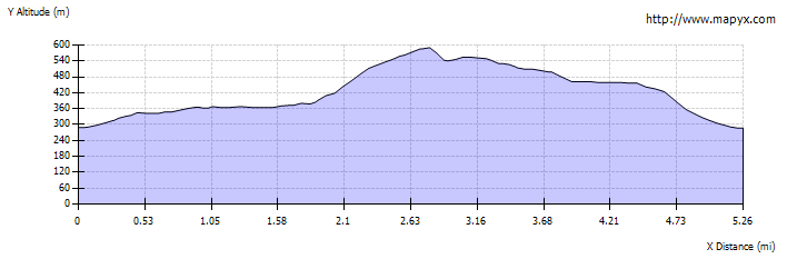
As the path curves round the hillside Ullswater comes into view, first just the Glenridding and
the southern end - then the whole length of the lake. The path descends to follow a stone wall for about one
mile.
|

|
Where the path divides, take the left fork, away from the wall and towards Dockray, which can be seen in
the distance. If you have parked by the quarry on the A5091 below Dockray, continue to follow the wall, which
should lead back to the car park.
Closer to Dockray walk downhill to cross a small stream. Keep the stream to the left and continue downhill. Cross another stream
and turn right on to track through wooden gate. The track meets the road by a telephone box. Turn left to return to the Royal, or
right if you wish to walk back along the road to the car park by the quarry.
|