View Larger Map
The route follows clear footpaths, many of which are steep and uneven.
Heptonstall Wikipedia
Heptonstall village website.
| Map: | Sheet OL21 South Pennines |
View Larger Map |
| Start: | Car park at entrance to National Trust estate(SD988291) off the A6033. | |
| Route: | Click here to view the route superimposed on GoogleEarth
(GoogleEarth must be installed on your computer
in order to view - click here to download GoogleEarth).
The route follows clear footpaths, many of which are steep and uneven. | |
| More info: |
Hardcastle Crags National Trust website Heptonstall Wikipedia Heptonstall village website. | |
| Refreshments: | Gibson Mill, and also pubs and tea room in Heptonstall (see village website for details). | |
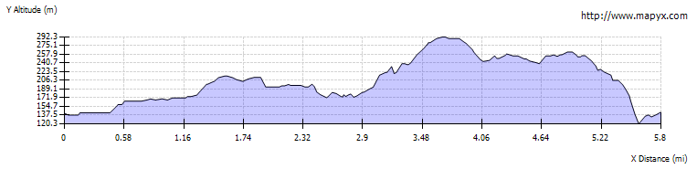
| Route profile: |
|
|

|
From whichever car park you use, follow the sign for Mill Walk. The path leads down to the river. | |

|
Follow the path which stays closest to the river upstream, this involves a number of sets of steps, as well as steep paths. | |

|
From the mill follow the track which is signposted to the Crags. After about half a mile the track forks. Take the left fork, which is level then leads back down to the river. Turn sharp left and cross the bridge. | |

|
Follow the path back downstream, crossing the river by bridge, then crossing back almost immediately. | |

|
The path brings you back to Gibson Mill, but on the opposite side of the river. At a junction of tracks close to bridge, take the right fork which is signposted for Heptonstall. This leads diagonally up the hillside, gradually becoming narrower. | |

|
As the path levels out, it runs below the stone boundary wall of the wood, look out for the stile shown here. Cross the stile and follow the footpath at the side of fields, with a stone wall on your right. Cross a couple of stiles then look out for an opening in the stone wall on right. Turn left and emerge on road. Turn left on to the road, but almost immediately turn right to cross open land, heading towards a telegraph pole. Cross the road opposite two tracks. Take the left hand of these tracks, towards a row of cottages. Turn left to walk in front of the cottages, then at the far end of the row turn right, following sign towards Lumb Bank. The track meets the Calderdale Way - continue ahead. | |

|
As the track turns to the left, take path on right, signed for Heptonstall. This path enters Eaves Wood, which it skirts the edge of, with some interesting rock outcrops and spectacular views across Colden Clough. Look out for footpath sign on left, pointing towards Heptonstall. The path runs between two stone wall, before opening on one of the network of streets in this intriguing village. | |

|
Take time to explore the village (visiting the
museum, if open). We enjoyed an afternoon tea at
the Towngate Tea Room - there are also two pubs in the village. Leave the village by walking along Northgate, with the Cross Keys on your left. Pass the Methodist chapel on your right, before follow the bridlepath sign on the right, opposite Northfield Terrace sign. The path enters woodland, crosses a minor road, then brings you close to Hebden Water at Midgehole. Walk upstream following the river to cross the bridge and return to car park. |
Back to: