| Map: | Sheet OL1 Peak District - Dark Peak area |
| Start: | Fairholme Car Park, Upper Derwent Valley (off the A57, Snake Pass). There is a charge for parking on this car park - which seems fair enough to me - there are toilets and a shop serving snacks 7 days a week.(SK6172893) |
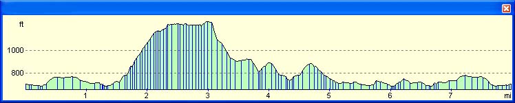
| Route: | The route starts off along the level road alongside the reservoir - but then climbs steeply. It follows the contours about 300 feet below the ridge, then drops down to the Ladybower Inn. Most of the return route is along the track by the reservoir. |
| More info. |
Wikipedia entry for Ladybower Reservoir.
Wikipedia entry for Derwent Edge. |
| Refreshments | At Fairholme car park and the Ladybower Inn |
|
|
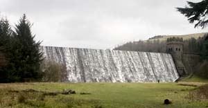
From the car park, walk along the path leading towards the river. Turn right on to the road which crosses the river. You can't miss the spectacle of the Derwent Reservoir dam to the left. Continue along the road which follows the eastern shore of the reservoir. Notice the information board close to where Mill Brook empties into the reservoir. The board provides information about the flooded village of Derwent. The road becomes a track, and about 500 metres beyond the information board a track and footpath lead to the left. Go through the wooden gate and follow the footpath which is signed Derwent Edge and Moscar. |
|
|
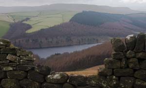
The paved path climbs fairly steeply above Grindle Clough, then passes through a wooden gate to skirt a stone building. On the left is a shelter provided by the National Trust. The path drops down to cross a stream, leads through two wooden gates, then passes to the left of a small pine plantation. The next gate leads to access land, where the path becomes slightly less steep. As you walk towards the next (metal) gate, straight ahead on the horizon the Wheel Stones are visible. Other gritstone formations can bee seen along Derwent Edge. |
|
|
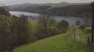
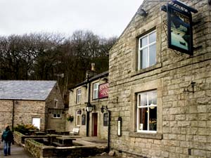
When you pass through the metal gate, turn right along a track which contours round the hillside with a stone wall on the right. Continue along this track for about half a mile - the wall becomes a fence, which drops down to the right. Continue along the path until you reach a junction. Turn sharp right on to a path which descends steeply. The path bends round to the left, then levels out as you enter woodland. At Ashopton follow the track straight ahead - there are views of the southern arm of the reservoir to you right. The mouthwatering smell of cooking from the Ladybower Inn should let you know that you are near. When you meet a track, turn sharp right to descent to the road. The Inn is on your right. |
|
|
We had a very enjoyable lunch at the Ladybower Inn, before returning to Fairholme. On leaving the pub we retraced our steps, turning left up the track and then laft again. When we entered the wooded area at Ashopton, we took the left hand fork, which drops down to the track by the reservoir shore. We followed this back to the car park - an easier walk than the walk to the Inn. |
Back to:
Walks Index
Graham & Lin Dean's Home Page