|
From the car park, turn left towards the village. Cross the road, and take the footpath leading over the clapper bridge.
Turn right on to Pennine Way and cross stiles. After about 300 metres take the path on the left, following
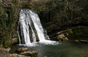
fingerpost which reads, Janet's Foss 1 mile. Follow this path up the valley and then continue
through wooden kissing gate to enter a wood. Shortly after the waterfall, the path emerges on to a road. Turn right along the road.
|
|
|
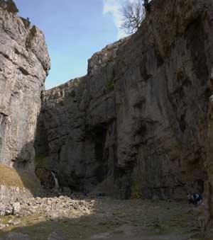
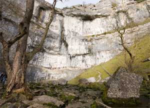
Where the road bends to the right, follow the track on left, through a campsite. The track winds between the stream and the cliff
face to enter the deep gorge. We joined the queue to scramble up the rocks at the at the centre of
the gorge. Although the scramble is quite short, the rocks are stepp and can be slippery. Above the waterfall, the
going becomes easier (but is still steep). Eventually it leads out of the gorge out onto a plateau.
Follow the clear path towards a wall, but don't cross the first stile on left. Continue walking
parallel to the wall until reaching the corner of the field. Cross the stile on the left and walk along
the road heading west for about 600 metres.
|
|
At a finger post to the right of the road take the path left, away from the road,
following sign, Malham Raikes 1½ miles.
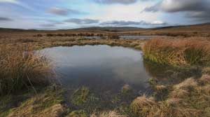
Walk for about 440 metres to cross a ladder stile. Continue in the same direction, then follow finger post
pointing to Malham Cove, skirting the pool pictured left. The path follows a shallow depression down to a
ladder stile. Follow the path through a gap in a stone wall, then over another ladder stile. Turn right at another
finger post pointing towards Malham Cove.
|
|
The path leads to a ladder stile and then on to the extensive area of limestone pavement above
Malham Cove. Cross the pavement, stepping carefully on the clints (the blocks of stone), avoiding
the grykes (the gaps between the clints). At the far end of the pavement follow the path down steep steps
to the valley bottom. It's then an easy walk along the popular path back to the road. Turn right on to
the road to return to the village and National Park Centre.
|