| Map: | Sheet OL27 North York Moors: Eastern Area |
| Start: | Park on the roadside in the village of High Hawsker (927076) |
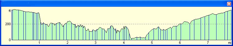
| Route: | High Hawsker is about a mile across field paths to the Cleveland Way. The coastal path contains a fair amount of climbing,
as it dips up and down
following the clifftops, however, the return journey is along a very gentle incline of a disused railway. The walk may be started from Whitby, in which case I would recommend also walking in the opposite direction, so that the final leg is still along the disused railway. |
| More info. | . |
| Refreshments | A huge variety to choose from in Whitby. |
|
|
From the road junction in the village, follow the road north east. Take the bridlepath on the right, almost opposite the Hare and Hounds pub. It is situated just before a bus shelter and post box. The track soon crosses a bridge over the railway path. Follow the track to Gnipe Howe Farm. Here the bridlepath turns left, but the footpath we followed passes through a metal gate on the right, then crosses the corner of a field, to a stile. The path heads directly towards the cliffs. Turn left to follow the Cleveland Way along the clifftops. |
|
|
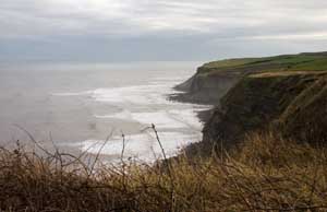
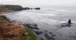
The path follows the line of the clifftops behind a lighthouse and then in front of the former fog horn station. It skirts Saltwick Bay and then passes through a large caravan site. When the path meets a road, turn right and skirt the boundary wall of Whitby Abbey. |
|
|
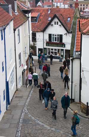
At the end of the road, either take toe steep path by the abbey walls, or enter the churchyard and descend via steps. Continue along the narrow, shop-lined street which leads out of the town, following close to the east bank of the river. The road climbs uphill to a crossroads. Go straight across the main road, following signs for the cycle route. After passing housing and a cemetery, the road goes under a railway bridge. Turn right off the road before the bridge, then left to join the disused track. Walk along the track bed away from the river. Continue along the disused railway for about 2 miles, passing the village of Stainscale and a cycle hire establishment. Where the cycle route meets the main road, turn right along the road. Take the first road on the left to return to High Hawsker. |
Back to:
Walks Index
Graham & Lin Dean's Home Page