|
Leave the park walking back towards Winewall.
|
|

|
Turn left over the bridge and walk up the hill, passing the Cotton Tree Inn on your left.
|

|
Follow the road round to the left in front of the post box.
|

|
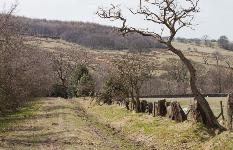
A little further up the hill the road bends to the right. Look out for a small footpath sign on a metal post at
the right of the road. It points across the road through wooden gates in the fence above the house pictured. Walk along
the gravel driveway…
|

|
… on to the grassy path shown above. The path curves to the right and then follows a stone wall above a disused quarry on the right.
The path leads through a gated stile into a field which provides splendid views with Boulsworth Hill in front of you and
Pendle Hill behind.
|

|
Leave this field by climbing a sturdy stone stile, hidden at first behind the dog-leg in the wall on the left.
Cross the minor road (Keighley Road) and climb the stone stile opposite. The footpath runs to the left of the drive.
Where a footpath sign on a wooden post points to the right, cross the drive…
|

|
… and walk between outbuildings on the left and the house on the right.
Go through the metal gate pictured, turn left and pass through a wide metal gate.
Bear right across the field to a stile close to the far corner. Climb the stile …
|

|
… and follow the line of a post and wire fence on your left. Leave this field by way of another stone stile.
Cross a footbridge and walk up to a stile in the wall on the right (just before a gateway and cattle grid).
Cross the drive and …
|

|
… bear left into a very wet, muddy field. The path isn't clear on the ground, but the map shows it running close
to the wall on your left. Leave this field by walking through a narrow, rickety gate. In the next field…
|

|
… the wall is on your right. Continue ahead and pass through the gap in the wall shown in the photograph.
Leave this field and turn left to follow the narrow road.
|

|
Turn right to enter car park. Keep left in the car park to join footpath down to village.
(We walked through the car park and found picnic bench to sit at whilst eating our lunch).
|

|
The cobbled path leaves the car park and runs close to the road.
|

|
The roadside path ends at a junction of footpaths with the road. We climbed the wooden stile straight ahead.
We continued in the same direction to walk through a gap in the vaccary stone wall (Wycoller is noted for walls of this type,
constructed from upright stone slabs). Bear slightly to the left, looking for …
|

|
… the wooden stile pictured above. After crossing the stile the path descends fairly steep steps to emerge in a
yard at the side of a cottage. Go through wooden gates and turn right…
|

|
… to walk along the surfaced road. This leads past the craft centre/tea room, a packhorse bridge, a ford and a clapper bridge.
We stayed on the right of the stream to follow the path shown …
|

|
… which lead past and through willow sculptures created from living saplings in 2004.
At the end of the tarmac footpath we turned right to walk along a stony track.
|

|
Follow the track alongside Wycoller Beck until you reach the clam bridge pictured above. Go through gate and
stile to cross the bridge and turn right at the far side.
|

|
The track crosses the stream and leads to the junction pictured above. Keep left, following the way markers for Parson
Lee Farm.
|

|
Close to the farm buildings (which are on the right), take the footbridge on the left and pass through a wooden gate.
Once through the gate bear left, making for a post with a waymark.
|

|
Head toward the front of buildings at Foster's Leap Farm. Foster's Leap is the name given to the rock outcrop
above the farm, reputedly named after Foster Cunliffe, (a relative of the Cunliffes of Wycoller Hall). He made a daring jump across
the gap in the rocks. Leave this field via a gateway (very muddy area when we completed this walk). Follow the arrows
around the building and …
|

|
… through gateway. Follow the yellow arrows along the driveway and …
|

|
… then down to the left of a pond towards a wooden kissing gate in a stone wall.
|

|
Follow the path round the side of the hill, passing through a series of gates
|

|
The path leads to the edge of a car park and to the Atom, one of a series of sculptures across Pennine Lancashire.
|

|
Leave the Atom by following the path which leads north west. Pass through a gate in the stone wall and bear left,
following the sunken lane down the hill.
|
|
Continue downhill until you reach a sign pointing left to the aisled barn. Turn left and then right …
|

|
… to explore the barn (if open).
|

|
After leaving the barn, explore the ruins of Wycoller Hall (reputed to be the Ferndean Manor in
Charlotte Brontë's Jane Eyre).
|

|
From the hall, follow the path alongside the beck and cross the clapper bridge, the ford or the packhorse bridge.
Follow the road past the craft centre/tea room. Continue along the road as it crosses and then recrosses the beck.
Immediately after the second bridge (where the road turns sharp left) …
|

|
… take the track on the right, past the houses pictured. The track bears right and crosses the beck once again.
Continue along the track, crossing a stile by a house on the right.
|

|
The path continues through an area newly planted with hundreds of saplings. Along this section there is a kissing
gate to pass through, followed by a short paved section of path.
|

|
At the junction of paths shown above, go left through the wooden gate. The path leads through further
gates and crosses a narrow road.
|

|
Cross the bridge pictured, and after 150 metres cross another bridge. Follow the path up stone steps and then
down to cross a wooden footbridge.
|

|
The path passes through a local nature reserve - the lodge pictured is the higher of two. The water from these
once served one of the largest tanneries in Europe (demolished in 1970). The path continues past the lower lodge and
back to the car park. |