|
From the pay and display car park, walk back to the road and turn left. At the road junction turn right on to
Blackburn Road. Just after passing the Ribchester on the left, turn left to follow a narrow road (Stydd Lane) leading to Stydd.
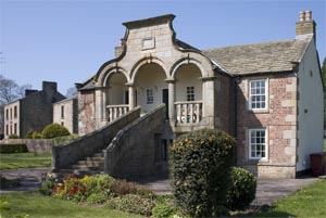
There are two interesting buildings along this short stretch of road. The first is the
Stydd Almshouses on the left
|
|
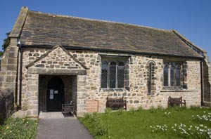
Just a little further along the road is one of the earliest church buildings in the area:
St Saviour. Continue north along the road to Stydd Manor Farm. Go through the metal gates which
have the words "foot path" painted on the top rail. After the farm, the road becomes a rough track.
Where there are two sets of gateposts ahead, go through the pair on the right (when we completed
this walk there was a broken stile and half of a circular footpath sign by this gate.
|
|
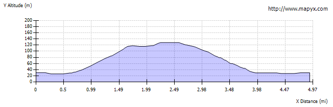
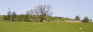
There is no clear path on the
ground, but continue to walk in the same direction. As you enter each field, the stile or gate leading to
the next is usually easy to find. The photograph shows the transmitter mast at the top of the hill. When you
reach the top, walk between buildings to join track leading to the road. Cross the road and climb stile opposite.
Another stile leads to the next field, then a metal kissing gates takes you into the wood.
Turn left along the drive, go over bridge across stream, then take path on right. This leads to a stile over wire fence, to leave the wood.
There are three public footpath markers. Follow the direction of the leading slightly south of due west, leading to
the corner of the woodland ahead. There is no clear path on the ground - don't be mislead by the gate into the
woodland to the south of the stile that you need to cross. A wide metal gate leads to a path, which in turn
emerges on a minor road.
|
|
Turn right along the road and follow it to its junction with the B6243. Turn left. Here we had a
pleasant surprise - the Health Rack gift shop was open, and ice creams were on sale!
Continue along the road for about 200 metres, then climb a stile on the right. Cross the field to
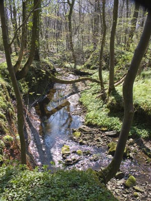
climb another stile, then follow path along edge of wood. Climb another stile on right to enter the wood and
follow path down to a stream. Cross the stream (there were convenient stones, so we didn't need to paddle).
Follow the path up to a stile, but don't cross it, instead follow the footpath to the left. This path takes you across
two footbridges, before ascending to the left of Duddel Brook and crossing a stile to leave the Woods.
Cross 2 fields and 2 stile to emerge on minor road (Gallows Lane). Turn right and follow the road until there is
a stile on the right. Cross three fields, climbing two more wooden stiles to meet other paths from left near
a footbridge. Cross the bridge and follow path to left. This leads in the direction of the stream, to emerge on
Stydd Lane. Turn left and re-trace your steps back to the car park.
|