| Map: |
sheet 287 West Pennine Moors. |
View Hurst Green in a larger map
|
| Start: |
Hurst Green (SD686378), car parking by the roadside. |
| Route:
| click here to view the route superimposed on GoogleEarth
(GoogleEarth must be installed on your computer
in order to view - click here to download GoogleEarth).
The route leads along field and riverside paths, with short stretches along the road. Most of the walk is level, or gently uphill, but there is a steep,
stepped path down to the river. Some of the paths can be very muddy following wet weather. |
| More info: |
Hurst Green Wikipedia
There are a number of listed buildings close to the route
along with strong literary associations: Tolkein is believed to have based many aspects of Middle Earth on the local landscape. He
wrote part of Lord of the Rings whilst staying at Stonyhurst, visiting his son who was a teacher at the college.
Tolkein isn't the only literary link: the poet Gerald Manley Hopkins taught
at Stonyhurst and Arthur Conan Doyle was pupil (Moriarty was a fellow pupil and his Baskerville Hall is said to be based on Stonyhurst).
Today the college is an independent Roman Catholic boarding school. |
| Refreshments: |
there are three pubs in Hurst Green (the
Shireburn Arms, the Bayley Armsand the
Eagle and Child) along with a club which advertises ice creams and teas at weekends.
|
|
|
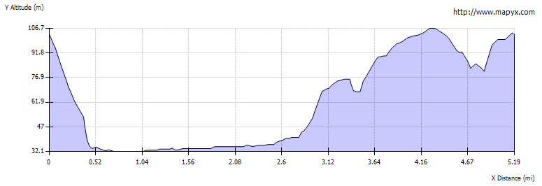
| Route profile: |
|

|
From wherever you park, make your way to the war memorial and then to the Shireburn Arms (out of the picture to the right).
|
|

|
Follow the track to the left of the Shireburn Arms, passing the hotel car park.
|

|
Walk through the wooden gate ahead and keep to the right of the field.
|

|
Part way down this field a footpath marker on
a wooden post directs you to cross the small stream on right. Continue walking downhill, staying close to the small stream.
|

|
Follow the stream towards an area of woodland.
|

|
A short stretch of boardwalk leads to a wooden stile, a footbridge and shallow steps up, which lead to a small field.
|

|
Walk down the field towards the gate and stile. Climb the stile to enter woodland and turn left along the Ribble Way.
|

|
A steep, muddy path, with steps in places, leads down to....
|

|
... a footbridge. Cross this to join the path by the river.
|

|
The path passes one of the pipelines on the Thirlmere Aqueduct, part of the Victorian aqueduct carrying water from Thirlmere in the Lake District to
Manchester.
|

|
As the path follows the meanders of the river, there are splendid views of Pendle Hill.
|

|
The path leads through a variety of gates, and the surface varies between grass and surfaced tracks as shown here, opposite Brockhall Wood.
|

|
Look out for the impressive early 17th century Hacking Hall, a Grade I
listed building on the opposite bank of the Ribble — it's just before the confluence of the River Hodder with the Ribble shown in the
photograph. It is thought that the author J.R.R. Tolkien may have used the ferry that operated here until the 1950s
as inspiration for Bucklebury Ferry over the Brandywine river in his Lord of the Rings.
|

|
About half a mile further along the River Hodder joins the Ribble. The path follows the Hodder for a short distance before...
|

|
... you turn left to walk between buildings at Winkley Hall Farm. Winkley Hall Farmhouse and cottage are also listed
buildings (Grade II). Bear right through the metal gate, then follow the track to the left.
|

|
The farm track leads uphill through a wood. Look out for the metal kissing gate on your right (see photograph on the next page).
|

|
Walk through the kissing gate and cross one field, pass into a second field where the path at first continues to lead uphill, before
descending ...
|

|
... to give views across to St Mary's Hall and Stonyhurst College. The path follows the edge of the wood before leading to...
|

|
... a stile. Cross the stile and cross the B6243 to walk along the unclassified road ahead (signposted for Stonyhurst).
|

|
Follow the road for a little under half a mile before turning left to follow the track towards Hall Barn Farm.
|

|
Continue ahead between the farm buildings (most of these have listed status). Once past the farm the track has a stone wall on the left and sports fields
on the right. The main building of Stonyhurst College can be seen on the right. This was originally built as a home for the Shireburn family and
was donated by them to the Jesuits, as a new home for their college.
Where the track forks (just beyond a rather dilapidated cricket pavilion), take the left hand branch...
|

|
... which leads to the gate pictured. Follow the track through the gate. The track bends to the right towards buildings.
Turn left in front of the buildings and follow the track to the road.
|

|
Turn right and follow the road back to the starting point (and refreshment in one of the pubs).
|