View Green Gate, Troutbeck in a larger map
This involves a fairly steep ascent and descent, but the views are worth it. The paths throughout are clear and easy to follow.
| Maps: | Sheet OL7 The English Lakes - South Eastern area |
View Green Gate, Troutbeck in a larger map |
| Start: | NY398028 layby on Green Gate, Troutbeck. | |
| Route: | Click here to view the route superimposed on GoogleEarth
(GoogleEarth must be installed on your computer
in order to view - click here to download GoogleEarth).
This involves a fairly steep ascent and descent, but the views are worth it. The paths throughout are clear and easy to follow. |
|
| Refreshments: | There's lots of choice in Ambleside. At the start and finish, the Mortal Man in Troutbeck is not too great a diversion. | |
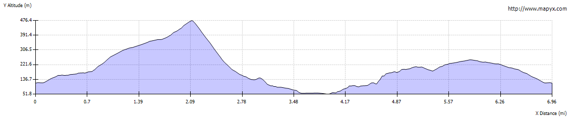
| Route profile: |
|
|

|
From the laybys on Green Gate walk towards Troutbeck (towards the west). At the junction with the main road through Troutbeck turn right. |
|

|
Look out for a finger post on the right of the road and turn left to follow the track pictured, signposted for Wansfell Pike and Ambleside. | |

|
The track leads out of the valley between stone walls. Continue along the track, passing through one gate, for about ľ mile. | |

|
About 300 yards beyond the gate pass through the metal kissing gate pictured. The path is now across open fell - but is still clear on the ground. | |

|
After about 150 yards proceed through the wooden kissing gate pictured. The path winds through open fell… | |

|
… gradually becoming steeper. This is a very popular route, hence the paving stones. | |

|
Most of the way up the steepest section there are splendid views over Windermere and beyond to Morecambe Bay (providing plenty of excuses to pause for a rest). | |

|
When you reach the top (a shame it's not marked with a trig point) there are equally spectacular
views in other directions. Follow the path through the gate and to the left of the rocky knoll. | |

|
The path then descends steeply round the rocky outcrop to a… | |

|
… a small cairn on the right. It then bends round to the left and continues to wind very steeply down the hill. | |

|
After a little under 200 yards the path leads through a gap in the stone wall and continues to lead downhill, becoming less steep. | |

|
Continue to follow the path downhill until reaching the stile picture (the stile can be avoided by using a gate to the right of the trees in the picture). When you meet a single track road turn left. | |

|
This road leads all the way to Ambleside, but it is worth looking out for… | |

|
… this gateway on the right, which leads into the woodland at either side of Stockgyhll Force.
Go through the gate and at a junction of paths turn right. Follow the path up to a bridge, crossing the beck, and then turn left to follow the stream downhill. There are various viewing points from which you can obtain a closer view of the falls. The paths were very uneven and washed away in places when we walked this route (possibly due to recent very heavy rain). | |

|
At the foot of steps shown in the picture, recross the stream and follow the path out of the woodland to rejoin Stockghyll Lane. Follow the road down to Ambleside where you emerge behind the former a Market House (now a superb Thai restaurant). | |

|
We spent some time obtaining refreshment and shopping, before leaving the centre of Ambleside, walking down Lake Road in the direction of the lake. | |

|
Continue walking down Lake Road until you arrive at the car park pictured. Cross the car park and turn right onto Old Lake Road. | |

|
At the end of the block turn left to follow Skelghyll Lane (there is a sign in the hedge which reads, Jenkins Crag - Skelghyll and Troutbeck (Bridleway). Continue to follow the lane, ignoring private drives until you enter... | |

|
… Skelghyll Woods. Follow the main track through the woods. The path is signposted Jenkin Crag. There is a bend to the right just before crossing Stencher Beck, then a bend to the left. | |

|
Look out for the diversion to the right of the track to the viewpoint over Windermere and towards
fells on the other side of the lake.
The path continues through the wood and then out on to the open fell. | |

|
Walk past the farm at High Skelghyll. | |

|
As you drop down from the farm you can see the route winding up the hillside ahead. | |

|
Where the path dips down between trees look out for the gate on the left. Go through the gate and follow the clear path uphill. | |

|
The path levels out and curves round to head south, south east before joining Hundreds Road. This track winds around the hillside to head east. | |

|
Where the track divides, follow the left fork (Robin Lane) if returning directly to Troutbeck. Take the right fork if you wish to pay a visit to the National Trust property at Townnend. | |

|
Robin Lane joins the road through Troutbeck next to the Post Office. Turn left along the road and then right to return to Green Gate. |
Other walks near here:
Back to: