| Map: |
sheet 287 West Pennine Moors. |
View Darwen Moor and River Roddlesworth in a larger map
|
| Start: |
SD679224 Sunnyhurst Wood car park, near the Sunnyhurst pub.
There are two alternative starting points with car parks:
SD665215 Roddlesworth car park, near Royal Arms and Roddlesworth Visitor Centre;
SD663202 Slipper Lowe car park. |
| Route:
| click here to view the route superimposed on GoogleEarth
(GoogleEarth must be installed on your computer
in order to view - click here to download GoogleEarth).
This does involve some short, steep climbs and a number of stiles. Most of the time it follows clear tracks and paths.
We completed the walk on a bitterly cold day in February - don't let the photographs dissuade you! On a clear day there are magnificent views
from Darwen Tower. The stretch alongside the River Roddlesworth (or Rocky Brook, as it is locally known) is picturesque in any season,
but particularly so when bluebells are blooming and the autumn colours are magnificent. We were rewarded with splendid icicles and ice formations.
|
| More info: |
Darwen Tower from Wikipedia;
Hollinshead Hall from Wikipedia;
| .
| Refreshments: |
The Sunnyhurst pub, Darwen; the Royal Arms and
Vaughn's Country Cafe (at Roddlesworth Information Centre), Tockholes.
|
|
|
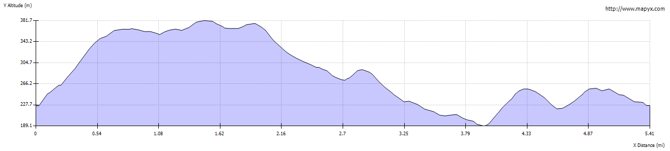
| Route profile: |
|

| From the Sunnyhurst Woods car park, walk back to the Sunnyhurst pub. Immediately opposite the path, follow the track on the right,
which leads between cottages and former farm buildings. Once past the cottages the track is sunk between high banks
and canopied with trees.
|
|

| The track emerges, passing a disused quarry on the left and providing the first glimpse of Darwen Tower ahead.
Pass through a gate onto the open moor and follow the path steeply uphill.
|

| Where the path forks, continue ahead (the right fork does rejoin the walk beyond the tower, and is a less steep ascent).
|

| At the next fork in the path follow the more distinct route, leading to the right. There is a stone direction
marker on the right of the path.
|

| At the next junction, our route leads to the right - but walk straight ahead to climb the tower, which provides magnificent
views to the west, north and east. Follow the path leading south west along the edge of the moor, overlooking two reservoirs
and Sunnyhurst Woods. A path joins from the right (the one mentioned earlier, which provides a more gentle ascent), and then
shortly after this our route turns to the left (where a narrower path leads over the fence ahead). At the next junction of
paths continue ahead (heading approximately south).
|

| Bear right at the next junction of paths (pictured) to pass through the gate.
|

| Where the path forks, take the path leading to the left. At this point the path leads south, but
quickly curves round to head west.
|

| Beyond the gate shown, the path zig-zags as it descends from the moor.
|

| Follow the path through another gate and then out onto a minor road. Cross the road and climb the stile immediately in front.
Turn left (the path on the right leads from Slipper Lowe car park, one of the alternative starting points).
|

| After a few yards, the path turns sharp right between trees and winds downhill. After a little over 200 yards/metres
you will see the ruins of Hollinshead Hall on your left.
|

| It's worth exploring the ruins, and looking through the widows of the well house. Leave the ruins following the track which
leads northwest.
|

| Just after leaving the hall ruins there is a junction of tracks. Take the right hand track which leads back uphill.
The track passes a wooden gate, before coming to a junction of paths...
|

| ... at which you continue ahead (the track on the right leads from Slipper Lowe car park). The path descends
to meet Rocky Brook by a stone bridge.
|
")
| Turn left to cross the bridge and then immediately turn right to go through a kissing gate.
|
")
| This section of the walk, where the path follows the western bank of Rocky Brook, is the most scenic,
whatever the season.
|
")
| The path crosses a small wooden bridge, before ascending steps. It then drops down again to the level of the
river.
|
")
| A path comes in from the left, just before you cross a concrete bridge.
|

| After just less than 100 yards, take a narrow path between trees on the right. This path leads steeply uphill...
|
>
| ... to meet a wider track. Turn left on the track and then almost immediately right, passing through
the wooden fence pictured. The path continues to climb quite steeply. When you reach the steps, there's not
much further to climb...
|

| ... before the path emerges on the road opposite the Royal Arms. The route continues ahead, between the side of the pub
and cottages. However we stopped to warm up in front of a fire in the pub. Refreshments are also available at Vaughn's Country
Cafe in the visitor centre which is through the car park to the right of the pub.
|

| Shortly after passing the pub, look out for the gate and footpath sign on the right. Cross a small field and climb a stile
next to a metal gate.
|

| Walk down the right hand side of the next, much larger field. Leave the field at the bottom right hand corner
to cross Stepback Brook. The path leads uphill through gates and over stiles, past the one remaining wall of
Lower Wenshead Farm...
|

| ... before climbing a final stile and turning left along the track. This leads past a former waterworks cottage and
back to the car park at Sunnyhurst.
|